Why the 2025 Pacific Northwest Flood Could Be Worse Than You Think — What History, Geography and Climate Models Say
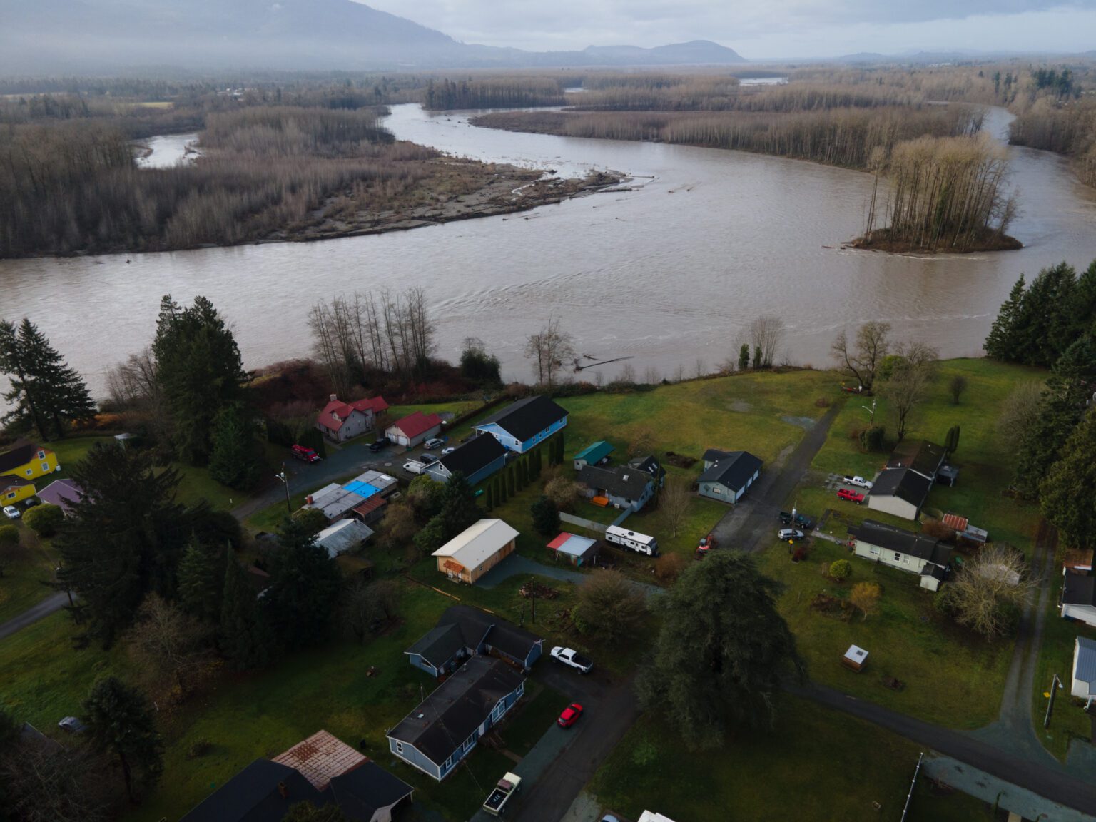
image credit: Cascadia Daily News
Introduction: A storm that’s more than a weather event
As heavy rain continues to pour across western Washington, a powerful atmospheric river has triggered flood warnings for dozens of rivers — including the Skagit County’s main artery, the Skagit River. But this is more than just another major storm: the conditions that have developed — geography, snowmelt, saturated soils, and shifting climate patterns — mean that this flood could have far-reaching consequences. For communities from Concrete to Mount Vernon and beyond, the danger may extend well beyond the next few days.
Many media reports have focused on immediate impacts — road closures, rising water levels, and rescue operations. That coverage is vital — but incomplete. To understand what’s really at stake, we need to look deeper.
Why the Skagit River is especially flood-prone
The Skagit watershed is not an average river basin. According to researchers with the Skagit Climate Science Consortium, there are several natural features that make the Skagit especially vulnerable:
- Steep slopes and dense drainage networks. The watershed drains a large area with rapid runoff. Water moves quickly from headwaters to main channels, leaving little time for soils or vegetation to absorb the flow. (Skagit Climate Science)
- Convergence of three major branches in a narrow zone. The Skagit’s three main tributaries join within just about eight river miles between Rockport and Concrete — concentrating flows and increasing flood potential. (Skagit Climate Science)
- Shift toward rain-dominated runoff. Historically, the Skagit’s highest flows occurred during spring snowmelt. But as winters warm, more precipitation falls as rain rather than snow. Scientists project that over time the watershed will shift to fall and winter peak flows — increasing flood danger during what used to be “low-risk” seasons. (Skagit Climate Science)
In other words: geography and hydrology alone make the Skagit highly flood-prone — even before considering climate change.
This storm: a “perfect storm” of flood drivers
What makes the current flood warning — and the warnings across western Washington and Oregon — more alarming than usual? Because multiple risk factors are stacking up all at once.
1. A powerful atmospheric river
The culprit behind the flood warnings is a long, narrow plume of moisture in the atmosphere known as an atmospheric river. This week’s AR has been rated at Level 4 on the 1–5 intensity scale by the Center for Western Weather and Water Extremes (CW3E) — meaning it carries a huge volume of moisture and lasts for days. (The Weather Channel)
Such AR events often deliver the majority of seasonal precipitation for the Pacific Northwest — when they hit hard, the impacts are national news.
2. Unseasonably warm temperatures + snowmelt
In many parts of western Washington and the Cascades, recent warm spells melted portions of existing snowpack. That melt — combined with heavy rainfall — adds significant runoff. According to a model cited by NASA and regional water scientists, this combination is particularly dangerous because snowmelt and rainwater reach the rivers almost simultaneously. (NASA Science)
3. Saturated soils, poor absorption, and flash-flood risk
The first round of rain saturated soils, filled small streams and creeks, and left little capacity for additional rainfall. As a result, water runs off quickly into rivers — creating sharp, steep flood “crests.” This rapid runoff also means urban flooding in low-lying neighborhoods, overwhelmed drainage systems, and increased flash flood risk. (AOL)
4. Terrain hazards — landslides, debris flows, burn scars
In parts of the Cascades and foothills, saturated soils and steep slopes raise the risk of landslides and debris flows. Areas with recent wildfire scars are especially vulnerable because burned vegetation does not hold soil the way healthy forest does. The fallout could include hillside collapse, destroyed roads, and cut-off communities. (The Washington Post)
5. Multiple rivers – not just Skagit – under threat
While much public attention centers on the Skagit, dozens of other rivers are forecast to reach major or near-record flood stages, including the Snoqualmie River, Puyallup River, Cowlitz River, Nisqually River, Skykomish, and others. (The Washington Post)
That suggests the potential impact area is much larger than media coverage focusing on a few rivers.
Where we still don’t yet know the full risk — uncertainty remains
- Flood-plain/basemap accuracy. Many flood maps were made decades ago, before recent climate changes and land-use changes (development, deforestation, fire). As rainfall and runoff patterns shift, the current flood-plain maps may underestimate real risk — especially for “unmapped” areas such as burn scars, new subdivisions, and low-lying urban zones.
- Cumulative impact of repeated storms. The current forecast includes not just one atmospheric river but a possible second surge later this week. A second round of heavy rain on already saturated ground increases the chance of levee failure, small-stream overflow, and cumulative damage — but such cascading risks are rarely analyzed in real time.
- Infrastructure resilience and evacuation readiness. Many articles mention road closures and rescues — but few evaluate whether local infrastructure (levees, drainage systems, emergency shelters) is prepared for sustained flooding or multi-day rescue operations.
What residents and authorities should do — immediate and long-term actions
Given the high risk, here’s what individuals, communities, and governments should prioritize:
- Monitor river gauges and official warnings continuously. The water-level forecast for the Skagit River has already been revised multiple times by the National Weather Service (NWS). (Cascadia Daily News) Use reliable local sources or official apps — not social media.
- Evacuate early if you are in low-lying or flood-prone zones. Don’t wait until floodwaters rise to your doorstep, especially if you’re near rivers, creeks, or in areas prone to landslides. Move livestock, pets, and valuables if possible.
- Avoid driving or walking through floodwaters. Many flood deaths occur when people attempt to drive on flooded roads. As officials repeatedly warn: “turn around, don’t drown.” (FOX 13 Seattle)
- Prepare for secondary hazards: landslides, debris flows, power outages, road washouts. Especially if you live on steep slopes, near burned areas, or below unstable terrain.
- Long-term: advocate for updated flood-plain mapping, resilient infrastructure, and adaptive land-use planning. Communities, local governments, and planners should update flood zone maps, reinforce levees and drainage systems, and integrate future climate-change projections in building codes and land use decisions.
- Promote public awareness about changing flood patterns. Residents should recognize that heavy winter rain — not just spring snowmelt — is now the new norm. Education on “rain-season floods” must become mainstream.
Why this matters — beyond the current storm
This flood threat isn’t just a weather event: it’s a wake-up call. The combination of atmospheric rivers, warmer winters, changing snowmelt, and shifting hydrology means that what used to be “once-in-decades” floods could become frequent events.
For the Skagit watershed and similar river basins, that means:
- More frequent spring and fall/winter floods — not just summer runoff.
- Increased pressure on levees, bridges, roads, and flood-prone infrastructure.
- Heightened risk of landslides and debris flows, which can cut off remote communities.
- Greater strain on emergency services, especially if disasters cluster (e.g., storms, snow, wildfires).
- Economic stress — farmland inundation, property damage, insurance issues, displacement.
Communities, planners, and individuals must treat these events not as isolated acts of nature but as part of an evolving pattern — and respond with long-term adaptation plans and resilience strategies.
Conclusion: The floodwaters are rising — in rivers, in risk, in urgency
In recent days, media coverage of flood warnings in western Washington has focused on rising waters, rescue operations, and immediate hazards. That reporting is essential. Yet it often misses the bigger story: that the current flood event is a symptom of deeper hydrological and climatic shifts — one that could reshape how we think about floods, seasons, and safety.
If you live near the Skagit River or any at-risk creek, stream or floodplain: don’t wait. Monitor updates, consider evacuation plans, and take steps now to protect your home, property, and loved ones. And if you care about your community’s future — ask local officials to update flood maps, invest in resilient infrastructure, and treat floods as a long-term challenge, not just a news story.
Because with a warming climate, heavy rain, and saturated soils — the next flood may be bigger, faster, and more destructive than the last.


Post Comment